
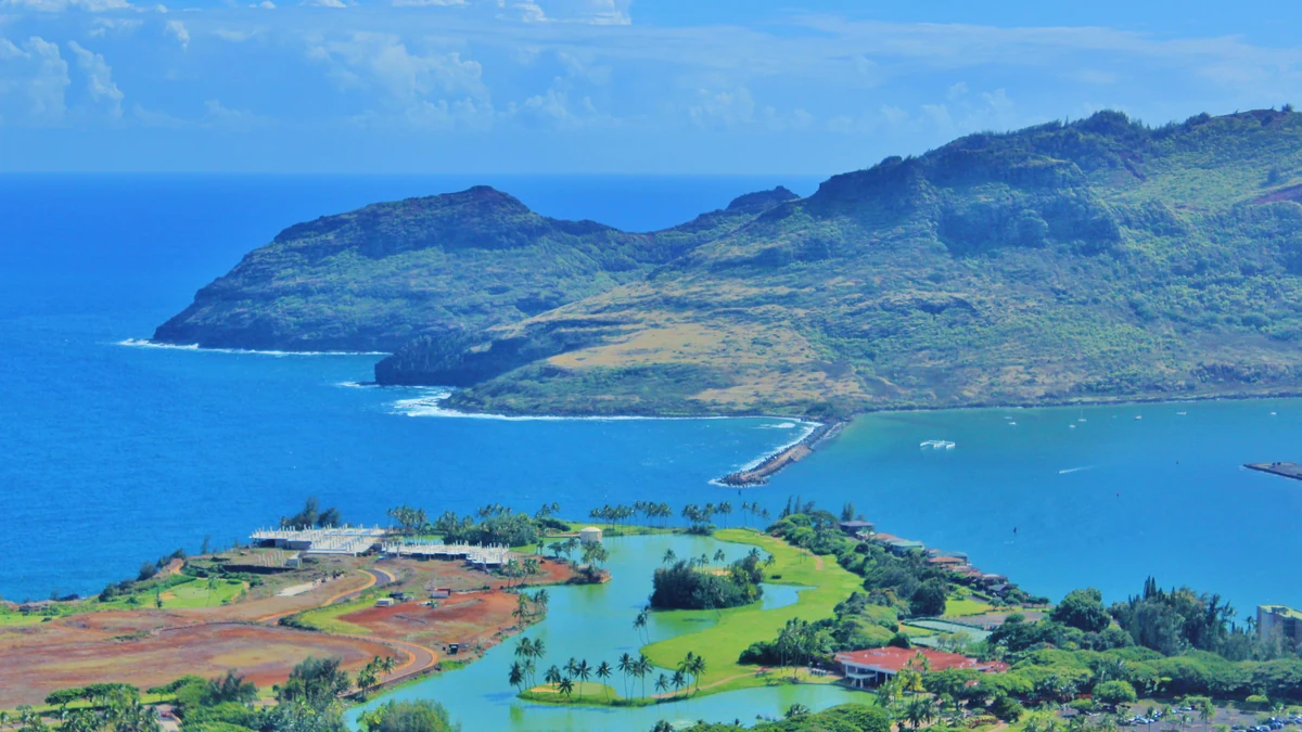
Nawiliwili cruise port is Kauaʻi’s working harbour gateway, close to Līhuʻe but not embedded in a walkable historic centre. Ships normally dock, which removes tender uncertainty, yet the island’s main experiences spread in opposite directions: Waimea Canyon and Kōkeʻe to the west, Wailua River and the east coast to the north, and beaches, museums and short scenic stops around Līhuʻe. The road network rather than the berth determines what fits.
The strongest plan chooses one side of Kauaʻi and protects the return. Driving distances can look modest, but low speed limits, single-carriageway roads, weather, bridge bottlenecks and parking make an island-wide checklist unrealistic. Confirm the ship in the Hawaiʻi passenger schedule, then decide whether the call is a west-side canyon day, an east-side river day, or a lower-risk local day around Līhuʻe and Kalapaki.
Nawiliwili Cruise Port at a Glance
| Port name | Nawiliwili (Kauaʻi), Hawaii |
|---|---|
| Main arrival area | Nawiliwili Harbor passenger berth near Līhuʻe |
| Cruise region | Alaska / North America / Canada |
| Country / Territory | USA |
| Currency | US dollar (USD) |
| Languages | English and Hawaiian |
| Port role | Day call and frequent overnight call on selected itineraries |
| Disembarkation | Docked |
| Walkability | Low from the commercial harbour; Kalapaki is the nearest useful walking area |
| Shuttle required | Usually helpful for Līhuʻe, shopping, rental collection or organised tours |
| Main transport | Ship excursions, rental cars, pre-booked tours, taxis, ride-hailing and Kauaʻi Bus |
| Best first-time plan | Choose Waimea Canyon or Wailua River as the main route, not both |
| Main caution | Traffic and long island roads make a late cross-island return much slower than the map suggests |
The Harbour Is Practical, Not a Destination District
Nawiliwili is Kauaʻi’s major commercial harbour. The gangway places passengers among port roads, security controls and transport collection rather than cafés and heritage streets. Cruise arrangements can include shuttles to nearby shopping or approved collection areas, but these vary by ship and call. Read the daily programme before assuming that a particular mall, rental desk or beach transfer is included.
This is one of those ports where walking out without a plan rarely reveals the island. Kalapaki Beach and the resort area are relatively close, yet route access, heat and the exact terminal exit matter. Līhuʻe’s museums and services are inland. Passengers who want scenery beyond the bay should treat the first movement—tour coach, rental shuttle, taxi or confirmed bus—as part of the day rather than as something to solve after disembarking.
Kauaʻi Splits Naturally into West, East and Local Days
The west-side route leads through Hanapēpē and Waimea towards Waimea Canyon and Kōkeʻe. The east-side route reaches Wailua, Kapaʻa and river experiences, with the north shore much farther beyond. A local route uses Līhuʻe, Wailua Falls, Kilohana, Kalapaki and nearby cultural sites. Each direction contains enough for a full call. Combining west and north is a poor use of a single day even with a rental car.
Choose according to weather and personal priority. Canyon views can disappear in cloud; river and waterfall landscapes remain compelling in showers but marine or kayak operations can change; a local day is more resilient when the call is short. The island’s appeal comes from its depth and landscape, not from ticking off every compass point. A route that leaves time to stop is more satisfying than a windshield tour of Kauaʻi.
Waimea Canyon Is the Big West-Side Commitment
Waimea Canyon is the obvious first-time land excursion for passengers who want Kauaʻi’s interior scale. From Nawiliwili, the route first runs west through towns and then climbs a winding road to the state park lookouts. The official state park page should be checked for current notices, access and parking. The drive is not technically difficult in normal conditions, but it consumes a substantial part of the call.
Do not judge the day by the first lookout alone. Visibility changes by elevation and time; one viewpoint may be clouded while another opens. A guided tour removes navigation and parking pressure, while a rental car offers flexibility to respond to cloud. Either way, agree a turnaround time before climbing. The canyon is worth making the main event, but it is not a sensible prelude to an afternoon on the far north shore.
Kōkeʻe Adds Elevation but Also Adds Risk
Kōkeʻe State Park continues beyond the canyon towards higher lookouts and trails. In clear weather it can deliver views towards the Kalalau valleys and a different upland environment. The road, parking and cloud conditions become more variable, and the additional distance can turn a comfortable canyon visit into a tight return. Check the Kōkeʻe State Park notices before committing to the upper route.
For a day call, think of Kōkeʻe as an extension earned by time and visibility, not a compulsory item. Passengers on an overnight may have more freedom, but the ship’s all-aboard still applies each day. Hiking should be conservative: wet red soil is slippery, trails can take longer than expected and mobile coverage is unreliable. A lookout-focused visit is often the correct cruise-day compromise.
Wailua River Is the Strongest East-Side Alternative
The Wailua River corridor offers a greener, lower-elevation day with boat trips, paddling, waterfalls and cultural landscape. Official visitor information describes the river as feeding both Wailua and ʻŌpaekaʻa falls. Commercial trips may combine a river boat or kayak with a walk, while self-drivers can link selected lookouts and Kapaʻa. The route is closer than the canyon but can still suffer east-coast traffic.
Choose one organised river activity and understand its physical requirements. Kayak-and-walk trips involve heat, water entry, uneven ground and sometimes mud. Boat-based outings are easier but operate to fixed departures. An independent driver should not promise both a river excursion and an ambitious north-shore visit unless the call is unusually long. The safe version finishes with a nearby viewpoint or Kalapaki rather than another long road leg.
Wailua Falls Is a Viewpoint, Not a Swimming Stop
Wailua Falls lies north of Līhuʻe and can be reached by road to an official overlook. It is a useful addition to a local or east-side route, especially after rain, and the official visitor page confirms it as one of the area’s recognised sights. Parking and viewing space are limited, so coach and car arrivals can create short queues.
Do not plan to descend to the base or swim. Unofficial paths are hazardous and are not a reasonable cruise-day activity. The stop is brief, which is why it works well with a museum, plantation train, river outing or scenic drive. It does not justify a dedicated expensive transfer by itself. Its value is as a controlled piece of a coherent route.
Kalapaki Is the Best Low-Complexity Beach Option
Kalapaki Beach sits near the harbour and resort area, making it the most practical beach choice when passengers want sand and water without crossing the island. Conditions, access and the safest walking route should be confirmed locally. Facilities in the resort district make the day easier than at a remote beach, but the beach is not directly outside every terminal gate and a short shuttle or taxi may still be the sensible movement.
A Kalapaki day works well after a morning excursion or when weather makes the canyon unattractive. It is not the place to force a snorkelling promise; water conditions vary and lifeguard coverage should be checked. Protect belongings, use strong sun protection and retain a straightforward return. Passengers who choose this deliberately can have a relaxed day; passengers who arrive there only because rental transport failed may feel they have missed Kauaʻi.
Līhuʻe Provides Culture and a Weather-Proof Backup
Līhuʻe is the island’s administrative and service centre rather than a polished resort town. The Kauaʻi Museum, local food, historic buildings and nearby plantation attractions can support a useful half or full day. Official destination information identifies Nawiliwili Harbor, Kalapaki and Wailua Falls as part of the Līhuʻe area, which makes this the natural fallback when a longer island excursion is cancelled.
Opening hours matter, particularly on Sundays and holidays. A taxi circuit can link two or three local stops more efficiently than waiting for public buses, but arrange the return. This is also the right scale for passengers with limited mobility or a short call. Do not apologise for staying local: understanding Kauaʻi’s history and landscape can be more rewarding than spending four hours driving to a famous viewpoint hidden in cloud.
A Rental Car Offers Freedom but Requires Advance Logistics
Rental cars are popular because Kauaʻi’s attractions are dispersed. The practical issue is collection. Airport and off-site offices may require a shuttle, taxi or approved meeting arrangement from the harbour, and opening hours may not match early arrivals or late returns. Reserve in advance, tell the company you are arriving by cruise ship and confirm exactly where the shuttle operates. Do not assume every airport branch collects at the terminal.
Download maps before leaving and keep fuel and return paperwork inside the schedule. Island roads are generally straightforward, but traffic around Līhuʻe, Kapaʻa and bridge approaches can stall. Parking at canyon lookouts and beaches can fill. The driver should not be the only person tracking time. Set a firm point to turn back, even if the next viewpoint looks close.
Ship and Independent Tours Solve Different Problems
A ship excursion is most valuable for long routes, fixed-departure boats and activities where a mechanical delay would threaten the return. Waimea Canyon, a major river trip or a north-shore itinerary can justify that protection. Independent operators may offer smaller groups and better pacing, but the booking must specify the ship, berth and all-aboard time. A generic hotel tour is not automatically cruise-compatible.
Compare actual route time rather than attraction names. Some tours spend long periods collecting passengers, shopping or waiting at viewpoints. Ask how many main stops are made, whether lunch is included and what happens in rain. A shorter private or small-group circuit can produce more useful time than a full-day coach with an impressive list. The best tour is the one designed around Kauaʻi’s roads, not the one with the most brochure nouns.
Kauaʻi Bus Is Useful but Not a Sightseeing Network
The Kauaʻi Bus schedules serve local communities and can support simple journeys around Līhuʻe and the east side. They are not a hop-on sightseeing system, do not reach every attraction and may not operate on the same pattern every day. Sunday service limitations and route timing can remove an apparently cheap option. Check the current timetable and fare rules close to the call.
A bus can be reasonable for one destination with a clear return, especially for experienced independent travellers. It is unsuitable for Waimea Canyon, a chained waterfall-and-beach plan or any itinerary dependent on a close connection. The cost saving is not meaningful if one missed bus consumes the afternoon. Use public transport where it simplifies the day, not merely because it exists.
Overnight Calls Need Two Separate Plans
Some itineraries remain at Nawiliwili overnight. That creates valuable flexibility, but it should not be interpreted as permission to ignore the ship’s first-day return instructions. Gangway access, security and transport availability may change overnight, and rental offices or buses may close well before passengers wish to return. Confirm whether the ship remains accessible throughout the night and whether a vehicle can be parked or returned after hours.
Use the extra time to separate directions: a west-side canyon route on the clearer day and an east-side or local route on the other. Do not duplicate the same long road simply because the ship stays. Evening options near Līhuʻe and Kalapaki are more practical than an unprotected late drive from the north shore. An overnight improves resilience when each day still has a defined boundary.
Rain and Cloud Should Change the Route Early
Kauaʻi’s weather varies sharply by coast and elevation. The harbour may be bright while the canyon is clouded, or Līhuʻe may be wet while the west side remains clearer. Look at live radar and park notices before leaving rather than treating the ship’s forecast as island-wide. Heavy rain can affect trails, river activities, visibility and road conditions even when the temperature remains warm.
A sensible hierarchy is canyon when upper elevations are open and visible; Wailua or Līhuʻe when cloud blocks the west; Kalapaki and museums when rain or traffic makes a long route unattractive. Helicopter and boat excursions are especially weather-sensitive. If an operator cancels, accept the safety decision and move immediately to the local backup rather than spending the morning searching for the same activity elsewhere.
Mobility and Heat Are Easy to Underestimate
Docking avoids the challenge of a tender, but the commercial terminal can still involve ramps, walking and vehicle steps. Canyon lookouts range from easy viewpoints to paths with gradients and uneven surfaces. River and kayak trips demand much more. Ask operators about the longest walk, toilet access and whether passengers must climb into a van, boat or helicopter without a lift.
Kauaʻi’s humidity and strong sun can make short walks tiring. Carry water and rain protection at the same time. A local private tour with Wailua Falls, museum time and Kalapaki can be adapted more easily than a large fixed coach. Mobility planning should preserve the island experience, not reduce the day to shopping because the transport questions were left too late.
Set the Return Buffer by Route, Not by Distance
A useful return buffer is different for each Kauaʻi plan. From Kalapaki or central Līhuʻe, an hour may provide substantial protection. From Waimea Canyon, Kōkeʻe or the north shore, the return should begin much earlier because one collision, bridge delay or heavy shower can slow the only practical road. The ship’s all-aboard time is the endpoint after vehicle return, shuttle transfer and terminal security, not the time to arrive at the rental office.
Agree the turnaround before the day begins and put it on every traveller’s phone. Rental passengers should know the fuel station and shuttle frequency; tour passengers should confirm that the operator monitors the ship rather than a generic harbour timetable. When the route is running late, remove the final stop immediately. Kauaʻi offers many good reasons to linger, but none is worth converting a beautiful day into a port-return emergency.
CruisePing Recommended Port Day
For a first visit with a normal day call and a favourable mountain forecast, choose a protected Waimea Canyon tour or a pre-booked rental car collected promptly. Visit two or three lookouts, add Waimea or Hanapēpē only if time permits, and begin the return before the schedule feels urgent. Keep the final stop near Līhuʻe or Kalapaki rather than extending north.
When the canyon is clouded, switch to an east-side plan built around one Wailua River activity, Wailua Falls and a controlled Līhuʻe or beach finish. Passengers who dislike long road days should choose the local version from the outset. The key CruisePing judgement is simple: Kauaʻi rewards depth in one corridor and punishes a late attempt to join the west and north on the same call.
Weather & Best Time to Visit Nawiliwili
Nawiliwili is warm year-round, but rainfall and cloud are more important than small temperature differences. The drier summer period often improves the odds for canyon views, while winter brings more variable showers and ocean conditions. Local topography means the west side, east side and high interior can experience different weather at the same time. A live forecast for the harbour is only the starting point.
Carry a light waterproof layer even on a sunny morning and use sun protection at exposed lookouts. Drivers should be prepared for wet roads and sudden visibility changes. The National Weather Service forecast and state park notices are the most useful final checks, supplemented by the operator’s route-specific advice.
| Month / season | Typical high | Typical low | Rain / conditions |
|---|---|---|---|
| January–March | 26°C | 19°C | Warm with frequent showers; upper elevations can be cloudy and wet |
| April–June | 27°C | 20°C | Generally improving conditions with mixed trade-wind showers |
| July–September | 29°C | 22°C | Usually warmer and drier, though brief showers remain common |
| October–December | 27°C | 21°C | Increasing rainfall and more variable sea and mountain conditions |
Practical Questions for a Nawiliwili Cruise Call
Do cruise ships dock at Nawiliwili?
Yes, cruise calls normally use the commercial harbour berths, subject to the current state schedule and ship instructions.
Can I walk from the ship to Līhuʻe?
It is not a useful city-centre walk. Use the ship shuttle, taxi, arranged tour or confirmed public transport.
Can I see Waimea Canyon and the north shore in one day?
It is technically possible on a very long day but strategically poor. Traffic and road distance make one direction the better choice.
Is Kauaʻi Bus suitable for Waimea Canyon?
No. The public bus does not provide a practical cruise-day route to the canyon lookouts.
What is the easiest nearby beach?
Kalapaki is the most practical close-to-port beach option, though the safest access and any shuttle should be confirmed locally.
What should I do if the canyon is clouded?
Switch early to Wailua River, Wailua Falls, Līhuʻe attractions or Kalapaki rather than driving uphill simply to confirm the cloud.
Useful Official Links for Nawiliwili and Kauaʻi
These official sources help confirm the call, local bus service, state park access, island attractions and live weather.
- Hawaiʻi passenger and cruise schedules
- Kauaʻi Bus schedules
- Kauaʻi Bus fares
- Official Līhuʻe visitor information
- Wailua River visitor information
- Waimea Canyon State Park
- Kōkeʻe State Park
- National Weather Service Nawiliwili forecast
CruisePing Port Verdict
Nawiliwili is an excellent gateway but a weak place to improvise. Docking is easy; reaching Kauaʻi’s defining landscapes takes planning. Waimea Canyon and Wailua River are both strong first-call choices, yet they belong to different route strategies. A local Līhuʻe and Kalapaki day is the intelligent alternative when time, mobility or weather argues against distance.
Choose one direction before leaving the ship, reserve the first transport movement and set a visible turnaround time. The avoidable mistake is trying to prove that Kauaʻi is small by driving across too much of it. The island feels richer when the schedule leaves room to stop.
Ready to browse our article library?
Explore more ports in the Alaska / North America / Canada region, narrow the library to USA cruise ports, or return to the main CruisePing article library.